| Relation Ship |
Project goals |
Szczecin Maritime University Team | Szczecin's Team Work |
Plan
of implementation |
Technical Information |
A team representing Szczecin Maritime University has undertaken a task of planning a route for an unmanned trimaran which will set out to circumnavigate the world. The route will account for various navigational, hydrometeorological and stability constraints. The preparations so far have included various preliminary assumptions, guidelines for the routing, offensive and defensive navigation tactics, analisys of safety and a route for all eight legs of the voyage.
The voyage round the world will consist of the following legs (ports of departure and arrival):
I. Lisbon - Canary Islands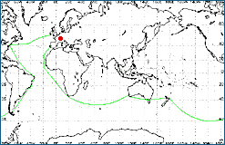
II. Canary Islands - Capetown
III. Capetown - Fremantle
IV Fremantle - Auckland
V. Auckland - Punta Arenas
VI. Punta Arenas - Rio de Janeiro
VII. Rio de Janeiro - New York
VIII New York - Ireland
While preparing the route of the trimaran, the following were taken into account:
- navigational safety,
- aero/hydrodynamic safety,
- general safety of navigation.
On the basis of general parameters of the trimaran an attempt was made to estimate its speed characteristics. Preliminary calculations indicated that in calm areas or on long ocean waves the trimaran is capable of developing a substantial speed of 23 knots, while at wind force 7 Beaufort scale the speed can reach 29.3 knots with a maximum heel < 15 degrees and full sails.
The assumed polar speed characteristics enables determining a mean trimaran speed in particular segments accounting for tacking in opposite winds.
The trimaran's route was prepared with such factors taken into account as statistical weather data, navigatonal information concerning particular areas with emphasis put on actual sailing routes of merchant vessels. The route comprises geographical coordinates of trimaran's turn points and general course values for subsequent route segments.
Lanes were defined for the allowed trimaran movement. These are dependent on navigational and aero/hydrodynamic safety (wind, currents, wave action). Such traffic lanes customarily are 60 Nm wide and run in a specific direction, e.g. South or West of the main route understood as the general course line.
While considering statistical meteorological data mean trimaran speeds were determined at each route segment within particular legs. On this basis passage times were estimated for particular route segments which made it possible to evaluate the total time needed to cover each leg of the voyage.
Characteristics of each leg were provided. They put emphasis on possible hazards in subsequent route segments. Charts with plotted courses have been attached.
The complex preparation of the trimaran's route also includes statistical weather conditions for particular legs (wind directions and force, wave action, currents) and a list of nautical publications, indispensible for the voyage planning and realization, that the centre controlling the trimaran should have at hand.
The map below presents the trimaran route devised by the Szczecin Maritime University team.
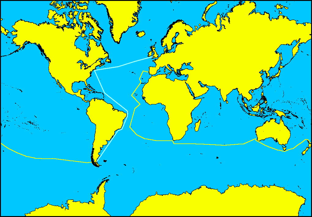
Click to get an enlarged part of the picture
The Maritime University team's accomplishments and problems concerning the implementation of the RelationShip project have been presented on 5 March 1998 at a Scientific Seminar organized by the Institute of Sea Navigation and during visit of Rector F.H. Furtwangen Prof. Walter Zahradnik in Maritime University on 6 May 1998.
Lectures were illustrated with computer presentations, including animation of the trimaran motions. The animations showed trimaran behavior on waves. One should note that the presented situations may occur when certain critical parameters are exceeded. These include wave height, steepness, length and speed.
Simulation 1 (sim_1.avi - 23,7 MB) Possible lateral capsizing around the submerged float (auth. A. Bak)
A side capsizing is likely to happen around the submerged float when the height of extreme transverse wave (parallel to the trimaran course) is equal or larger than the trimaran breadth. The ultimate element critical for this kind of danger is wave steepness. Unlike classical ballast yachts, which have a large stability of weight, the trimaran features form stability which ensures its parallel position on the wave slope. The steepness of ocean waves depends on the stage of wave formation and wind speed. It is expressed by the ratio H/l (wave height/wave length).
The yacht is likely to capsize at wave steepness larger than 1/7 for swell and more than 1/14 for wind-generated waves.
Simulation 2 (sim_2.avi - 1,8 MB) Capsizing over the bows I (running the bows into the opposite wave slope) (auth. T. Stecko)
The higher the trimaran speed is and the sharper its course (angle) in relation to the opposite wave is, the more the trimaran will tend to ?jump? over the wave crest, fall into the opening wave trough and run into the opposite wave slope. The trimaran may capsize over its bows when the wave length is equal or larger than the trimaran length.
Simulation 3 (sim_3.avi - 1,3 MB) Capsizing over the bows II (auth. T. Stecko)
A risk of losing the steerage way, turning and capsizing occurs in sailing when the yacht is on the leeward slope of the quartering wave 17-23 metres long, with the wave heading angle of 110-160o (so-called broaching). The two decisive factors are trimaran speed and wave steepness.
Simulation 4 (sim_4.avi - 1,7 MB) Capsizing on the quartering wave (auth. T. Stecko)
The navigational safety of the trimaran on quartering waves depends mainly on its speed which must be adjusted to the wave height, length and steepness.
![]()